
|
|
|
|
|
|
|
|
|
|
|
|
|
|
|
|
TIMED Overview
|
| TIDI Instrument Description TIDI consists of three major subsystems: four identical telescopes, a Fabry-Perot interferometer with a CCD detector, and an electronics box. Light from the selected regions of the atmosphere is collected by the telescopes and fiber-optically coupled to the detection optics. The four fields of view are scrambled along with a calibration input and converted to an array of five concentric cir-cular wedges. This input then passes through a selected filter, then through a Fabry-Perot etalon, and is finally imaged onto a CCD via a circle-to-line imaging optic (CLIO) device. |
|
TIDI System Mass: 41.8 kgElectrical Power: 19.32 watts (orbit average) Heater Power: 11.0 watts Data Rate: 2494 bits/sec Observations: winds, temperatures, and density Wind Accuracy: 3 m/s (line of sight) Altitude Resolution: 2 km Spectral Range: 550-900 nm Lifetime: >2 years |
Electronics System Hybrid Power supply80C51 (UTMC) Flight computer Data acquisition CCD controller Filter wheel/ shutters/ PWM heaters Telescope servo amp Calibration lamp power supply |
|
Telescope Specifications Off axis GregorianLow scatter optics and baffles Zenith gimbal Clear Aperture 7.5 cm Area 44.2 cm2 Angular FOV 2.5° horizontal x 0.05° vertical F/number 2.2 |
Profiler Specifications Fixed gap single etalonFabry-Perot interferometer 2 x 8 position filter wheel Circle-to-line image converter (CLIO) Passively Cooled CCD detector 5 x 32 Channels Clear Aperture 7.5 cm Plate Diameter 10.5 cm Gap 2.2 cm Finesse 8.1-8.9 |
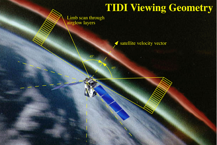
TIDI Data Acquisition Summary The TIDI telescopes perform limb scans through the terrestrial airglow layers throughout the satellite orbit. TIDI obtains these scans simultaneously in four orthogonal directions: two at 45° forward but on either side of the satellite’s velocity vector and two at 45° rearward of the satellite. These four views provide the measurements necessary to construct the horizontally resolved vector winds as a function of altitude within the MLTI region along two parallel tracks, one on either side of the spacecraft. Each vertical scan consists of individual views 2.5° (horizontal, along the limb) by 0.05° (vertical, normal to the limb) in angular size. The vertical altitude resolution of the instrument is 2.5 km, but the altitude spacing between views will be adjusted to yield a measurement vertical resolution of half a scale height throughout the limb scan. The altitude step size will range from 2.5 km in the MLTI region to 25 km in the thermosphere. Each up/down acquisition cycle will take 100-200 seconds to complete, resulting in a nominal horizontal spacing between profiles of approximately 750 km along the orbit track. The exact time per vertical scan will depend on the mode being run and the integration or dwell time needed at each altitude step. Each up/down scan cycles through a sequence of filter tunings, selecting the optimal emissions to be viewed within each altitude range to allow rotational and/or Doppler temperatures as well as neutral winds to be retrieved. More information about the dayside and nightside science modes being planned and their estimated accuracy (wind errors) as a function of altitude is given below in the TIDI Science Measurement Summary. |
 |
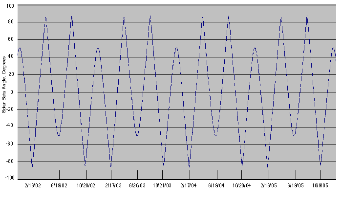
TIDI Coverage The precession rate of TIMED is such that it will take 60 days to precess 12 hours in local time (3° per day). On any given day there is little change in local solar time coverage at low and mid-latitudes. The most useful parameter for describing the TIDI local time coverage and viewing geometry is the solar beta angle, the complement of the angle between the normal to TIMED’s orbital plane and the earth-sun line. If the solar beta angle is 90°, then the normal to the orbital plane is parallel to the earth-sun line. If the solar beta angle is 0°, then the normal to the orbital plane is perpendicular to the earth-sun line. The variation in solar beta angle through the first two years of the TIMED mission is shown in Figure 5. |
 |
| The transition between TIDI dayside and nightside modes of observation
is made when the solar zenith angle (SZA) at the spacecraft reaches
90°. The solar scattering angle, the angle between the line of
sight to the tangent position and the sun, creates a secondary but
crucial consideration in the instrument operation. A TIDI telescope
will not perform observations if the solar scattering angle is less
than 15°, that is if the direction to the sun is within 15°
to the direction of the tangent position. This sun-avoidance criterion
prevents TIDI from directly viewing the sun. As long as the solar
scattering angle is acceptable (>15°), TIDI will seamlessly
continue data acquisition during the transition between day and night,
as the spacecraft passes through 90° in solar zenith angle. It
is possible for any number of the four tangent points (from none to
all four) to be in twilight at a given moment. The TIDI data inversion
technique becomes less successful when the tangent point viewed by
a TIDI telescope is in twilight. For twilight views, only line of
sight data products (Level 1 data) will be available; inversion products
(Level 2 data, such as altitude profiles of the neutral horizontal
winds) will not be produced. Consequently, optimum TIDI daytime observations are performed when: • the solar zenith angle at the tangent point is less than 80° • the solar zenith angle at the spacecraft is less than 90° • the solar scattering angle is greater than 15° Nighttime observations are performed when: • the solar zenith angle at the tangent point is greater than 100° • the solar zenith angle at the spacecraft is greater than 90° • the solar scattering angle is greater than 15° Figure 6 describes the relationship between the solar beta angle, the solar scattering angle, daytime/nighttime observations and TIDI coverage for a representative orbits. • symbols represent the local solar time/latitude of the tangent point at 100 km altitude • the hatched area corresponds to night; clear to day • the dashed lines indicate the boundaries of twilight (defined by the tangent point solar zenith angle being SZA = 90° ± 10°) • daytime observations are represented by solid symbols; nighttime by open symbols • red diamonds represent tangent points on the sun-side (warm side); blue hexagons are anti-sun-side (cold side) of the spacecraft |
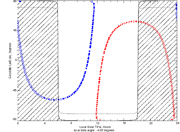 |
| The TIMED orbit (inclination 74°) combined with the four set azimuth angles of the limb-directed TIDI telescopes implies that there are two ‘turnaround’ latitude circles where the density of data acquisition reaches a maximum value. For an altitude of 80 km, these latitudes are roughly ± 58° and ± 90°. |
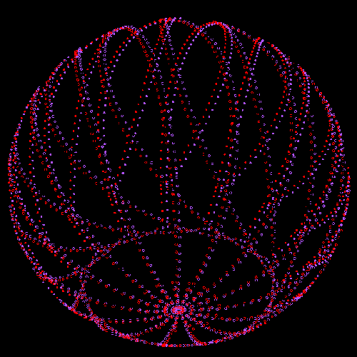 Figure 7. TIDI warm (blue) and cold (red) side tangent locations for a representative day, shown overlaying the globe. TIMED performs at least 14 complete orbits per day. |
|
TIDI Science Measurement Summary
Table 2. Scan Table Definitions
|